Because the Aeolian Islands are the ideal destination for trekking: discover 5 of the unmissable paths
Peaks with incredible views, beautiful trails immersed in the riot of colors of an unspoiled nature and lush, exciting walks on active volcanoes to admire the intense activity as privileged spectators: trekking in the Aeolian Islands is an experience you will not forget.
Each of the 7 islands of the Aeolian archipelago offers hikers different trekking itineraries, not always well signposted, which generally present a medium degree of difficulty both for the difference in height and for the condition of the paths. The temperate climate, typical of the Mediterranean islands, also allows you to take on various paths throughout the year.
Spring is undoubtedly one of the best times to enjoy the explosion of colors of the Mediterranean maquis and also to spot birds such as the herring gull and the queen’s hawk. The autumn will allow you, taking advantage of less high temperatures than the summer but with a sea still “warm”, to dive into the water at the end of your trek without other tourists around.
For those who choose summer, on hot days remember to hike very early in the morning or late in the afternoon, bringing plenty of water with you.
And here we are, camera in the backpack, ready for our tour of the five most beautiful and evocative paths of the Aeolian Islands.
Stromboli Crater, Stromboli (2h)
Stromboli is the island where the four elements – water, earth, air and fire – come together, leaving anyone passing by breathless.
The fountains of lava, the constant explosions and the rain of ash create, in fact, a wonderful natural spectacle that never fails to impress, all amplified by an exceptional scenic context.
Among the most beautiful and exciting experiences of trekking in the Aeolian Islands could not, therefore, miss the ascent to the crater of Stromboli – “iddu” – to observe closely the volcanic activity at night.
Since 2019, following two violent explosions, for safety reasons it is no longer possible to reach the highest point of the island. The current upper limit has been set at 400 m above sea level, only when accompanied by guides; alone it is possible to reach up to 250 m.
The itinerary, that we have covered with the guide, begins after the Church of S. Vincenzo in correspondence of the old cemetery, where there are some tombs dating back to the beginning of 900. We leave in the mid-afternoon in order to arrive at the panoramic point located to the north-west in time to watch the sunset, a prelude to an even more beautiful spectacle that will enrapture us at nightfall: the volcanic explosions.
The path proceeds initially between bends on a sandy bottom mixed with rocks and offers beautiful views of Piscità and Strombolicchio. Among Mediterranean scrub, terraces and streams we arrive at 400 meters, where we find the viewpoint of the Sciara del Fuoco, the wall on which pours the pyroclastic material emitted during the constant and frequent explosions of Stromboli.
Once arrived at the belvedere, the roars from the crater, which is only 350 meters away as the crow flies, make the contemplation of the sunset even more suggestive. When the light finally goes away the red of the lava becomes a magnet that captures our gaze, making it impossible to take our eyes off the lava fountains so close and imposing.
The climb takes a couple of hours and you can return to the starting point by taking the mule track of Punta Labronzo on the way back.

From port to Monte Filo dell’Arpa, Alicudi (2,5h)
Alicudi is the most remote and wildest island of the Aeolian Islands, a true paradise for hikers.
Here trekking is an integral part of life on the island: it is a daily routine for the Arcudari, its inhabitants, and a surprising experience for the guests who stay there. In Alicudi, in fact, roads do not exist and one moves by facing the steep steps that start from the port and connect both the houses and the six districts of the island reaching its top: every movement is transformed, in this way, into a tiring but suggestive trekking on lava stone steps. Whether it is a matter of reaching a house or walking along a path, the unit of measure, a singular peculiarity of the island, is always the step.
And with 1,700 steps, which gradually rising in altitude become higher and more challenging, we take you from the port to the top of the island, Mount Filo dell’Arpa (675 m), which owes its name to the harp, the buzzard in dialect. A unique trekking, which climbs the south-eastern wall of the island, insinuates itself among the beautiful Aeolian style houses, the rows of vineyards that here and there border the path and the abandoned terraces dating back to the beginning of the last century.
In Alicudi, vegetation and man’s hand blend perfectly in a scenario of rare and authentic beauty. Undisputed protagonist and companion during our ascent is the blue sea, increasingly intense behind us. One of the best points to admire it is the belvedere on which stands the small chapel dedicated to San Bartolo, about a third of the way.
After the last houses, the path becomes more impervious and uneven and you risk to lose it because of the vegetation that covers the tracks. Among ferns and stones, after the steep climb that from the port has never softened its slope, we arrive at a vast plain where every now and then some wild goats peep out, watching us with curiosity and fear.
The silence of this place is deafening and here, as in no other place, the solitary charm of this island emerges overbearingly.
A few more meters and we reach the panoramic point, at 670 m high. We look out and the Aeolus begins to blow energetically on our faces, while we enjoy a wonderful view from the top of the Bazzina district and to the east of Filicudi which clearly outlines its profile under the amber light of sunset.
The descent is made by retracing the path in the opposite direction, but pay attention to your knees that will be severely tested by the steps.
Ascent to Punta del Corvo, Panarea (1,5h)
Panarea, the most chic and worldly island of the Aeolian Islands, undisputed realm of entertainment and nightlife, hides a bucolic and authentic side that few people know. It is enough to go beyond the boundaries of the well-kept town, which extends close to the port, to immerse oneself, in fact, in the silent and generous nature that frames the three paths that cross the island.
Let’s take the itinerary that starts to the north of Panarea, near the Calcara beach. From the port follow the indications for the restaurant da Paolino; 200 m after passing the trattoria take the street on the left and continue until you reach a gate.
Here begins the path, immediately immersed in the Mediterranean scrub among mastic, heather, cistus and silene hicesiae, the beautiful flower with pink petals that grows only on this island. In the midst of the vegetation, you begin to see Basiluzzo and Stromboli that shyly show themselves to the north-east, behind the heliport of Panarea.
After the first half hour, the path becomes more exposed, overhanging the sheer wall in front of the Scoglio la Nave. Turning our backs, behind the gorse bushes in the distance you can see the hidden Ginostra, wrapped in a light white haze that contrasts with the golden lights of dusk. A fairy-tale image. We continue through the vegetation that becomes more intense invading the path, but it’s just a little further to reach the summit, Punta del Corvo (421m). The panorama now opens up over Filicudi, Alicudi, Lipari and Vulcano.
From here it is possible to continue by descending on the south side or by crossing the central part of the island. We choose the latter option and we enjoy along the descent a beautiful postcard of Panarea with its white houses surrounded by green, the small dots of boats in the roadstead and Dattilo on the right that are the background. The final stretch of the route is completely immersed in vegetation and ends next to the Raya disco.

Ascent to Gran Crater, Volcano (about 45 minutes)
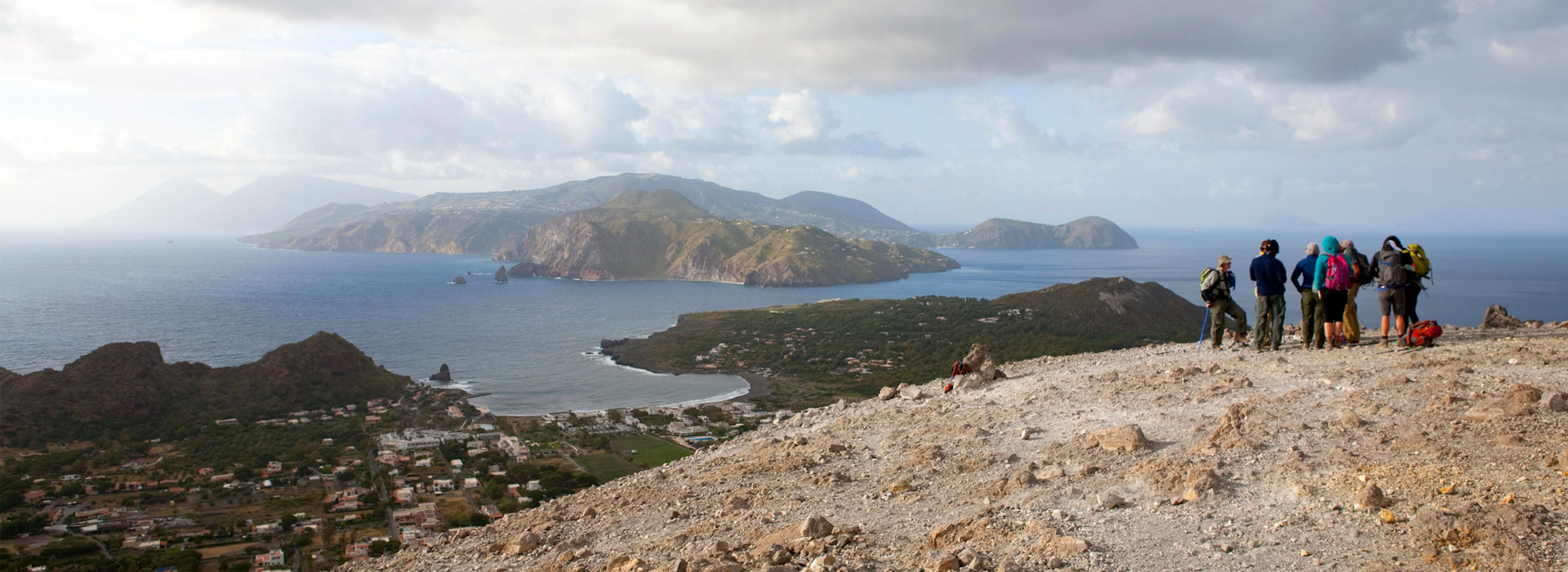
If the most beautiful and panoramic treks are usually the longest and most tiring ones, the path that leads to the Gran Cratere di Vulcano is certainly the exception that confirms the rule. With a walk of only about three quarters of an hour we can, in fact, admire the fascinating crater of an active volcano situated in one of the most panoramic points of the whole Aeolian archipelago.
The access to the path is located about ten minutes from the port of Levante along the road leading to the villages of Piano and Gelso. The ascent runs along the west side of the volcano on a ground of volcanic sand, surrounded by gorse bushes, which give way to clay tuff higher up. As you climb in altitude, the view opens up to Alicudi, Filicudi, Lipari and Salina. Arrived at the top, 386 meters above sea level, the other two islands, Panarea and Stromboli, also appear in our view, completing a wonderful “picture” to contemplate, especially in the light of dawn or sunset.
Behind us stands the crater with its 500-meter diameter and its particular yellow-reddish coloration due to the action of bacteria that interact with the sulfur of fumaroles. It is necessary to pay attention not to approach it too much both because the jets of vapor reach very high temperatures and because the sulfur is harmful to human health.
Fog from the fumaroles and a breathtaking view of the other Aeolian islands: the perfect setting for a series of photo shoots before setting off along the return route, which is along the same path.
From Valdichiesa to Mount Fossa delle Felci, Salina (2h)
The very green Salina, with its bucolic charm and the perfect geometry of its twin cones, now extinct volcanoes, is crossed by several trekking routes that connect the different places of the island. Here we will explore the path that starts from Valdichiesa (313m), a hamlet of Leni, and reaches the top of Mount Fossa delle Felci (962m), the highest point of all the Aeolian Islands.
The church of Madonna del Terzito, behind which the route begins, is 10 km from Santa Marina Salina and, in case you haven’t rented a scooter or a car, you can reach it with the island’s regular buses.
The path, taken care of by the forest, goes up through a forest of pines, chestnuts and oaks, and crosses in several points a road that can be a good alternative for those who are not used to medium-high slopes. The initial stretch offers a beautiful perspective on Malfa, with the church of the Immacolata and the vineyards all around. At the end of the climb, you cross a thick fern forest, from which the mountain takes its name. Finally, we reach the coveted panoramic point from which to observe Monte dei Porri, the twin cone on the slopes of which rises Pollara, the sweet valley of Valdichiesa, Lipari and Vulcano to the south and, finally, Alicudi and Filicudi to the west.
Calculate about 2h for the ascent, 1h30′ for the descent, which is done by the same path.
All that’s left to do is get your gear ready and go!

